Council to decide on permanent closure of West End track
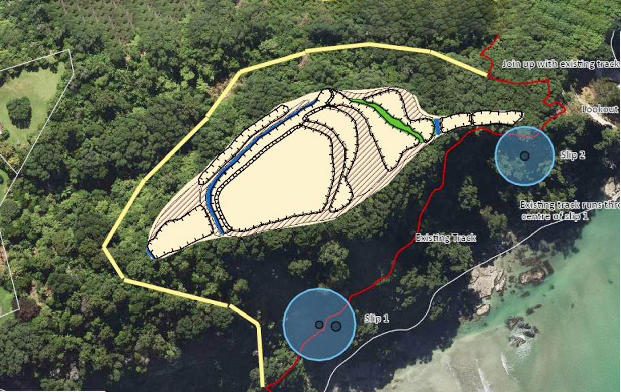
Staircase option: An alternative route for the Ōhope to Ōtarawairere track, (in light yellow) skirts a historic pā site but is still reliant on areas of track the council considers at high risk of being damaged by further slips,
Diane McCarthy
Whakatāne District Council staff are recommending the permanent closure of Ōhope’s West End track to Ōtarawairere Point Lookout and investigation of an alternative route.
A report, due to be received at a meeting tomorrow, recommends the council not fund the reinstatement of the track, which has been closed since October 2022, due to slips. Instead, it recommends investigating an alternative route (Route 2).
Route 2 over the escarpment, bypassing the two slips and the lookout point, would involve constructing a staircase rising almost vertically up the 70-metre escarpment face from the Ōhope end of the existing track.
It would approach a historic pā site on top of the promontory between Ōhope and Ōtarawairere and the council has identified it could provide opportunities to promote cultural awareness and the significance of this site.
There has been contact withNgāti Hokopū and Te Rūnanga o Ngāti Awa and site visits with archaeologists and hapū representatives. Agreement in principle for the realignment was given at a hapū meeting in October 2024.
Allowing a volunteer group led by Whakatāne residents Austin Oliver and Angus Robson to put forward a proposal to restore the current track at their own cost is among the options that have been put before council.
Mr Robson is unhappy the West End walkway volunteer group will not have the opportunity to speak to its proposal at the meeting.
“We’ve been disallowed from presenting our option at the council meeting on Thursday,” Angus Robson told the Beacon on Monday.
Mayor Nandor Tanczos urges people not to “jump the gun” over the issue as no decisions have yet been made.

He said the plans of Mr Robson and Austin Oliver’s volunteer group were clear to councillors from his previous presentation.
“Councillors were very aware of the strategic value of the track, both as a tourist destination and as a much-beloved place for people in the district.
“I can’t say what is going to come out of [Thursday’s] meeting, but I think councillors are very aware of the desire in the community to reopen that track,” he said.
“We’ve been given some ideas about how to go forward but we are also very aware that there are people in the community that have some ideas about how they think this could be done more cost effectively using volunteers.
“I think most councillors are very sympathetic to what they’re trying to do.”
Attached to the report are almost 150 pages of consultant’s reports, including geotechnical reports from CMW Geosciences, Avalon Geotechnical Services and Tonkin & Taylor, carried out between December 2023 and June 2025.
Two further reports by project design and delivery company reNature review a geotechnical report by HD Geo in September 2024 and investigate the potential realignment of the track over the hill.
Also included is a high-level review of these reports by WSP, dated December 2025.
The WSP report notes Tonkin & Taylor’s Quantitative Landslide Risk Assessment, which puts the annual individual fatality risk for a member of the public on the currently closed route as between one in 16 million and one in 1.5 billion.
This puts the risk within the “Low” category of guidance set out in the Bay of Plenty Regional Policy Statement and in the “reduce to as low as reasonably practicable” of guidance set out by the Department of Conservation and GNS Science.
The Tonkin & Taylor report indicates that this risk could be further lowered if the track was closed to the public during heavy rain events, which was when slips occurred.
It also puts the risk of further damage to the track from slips requiring costly repairs as high. This risk is lower for the alternative vertical staircase route; however, this route still relied on existing parts of the track at both the Ōhope and Ōtarawairere ends that were high risk.
The lowest-risk and lowest-cost option to council was identified as permanently closing the track between Ōhope and the lookout.
The council staff report notes this option “may have an impact on the local visitor economy”.
“But it is expected this would be marginal over the long term. Visitors and the community could access Ōtarawairere Bay from the existing track off Ōtarawairere Road,” the report says.
Community experience general manager Alexandra Pickles said staff made a recommendation based on technical inputs.
The volunteer group had already shared its views through public forums, meetings with staff, elected members and the community.
“The final decision rests with elected members, who can choose or amend any option, or propose something different.”
